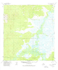
1954 Map of Medfra A-6
USGS Topo · Published 1978About this map
The Takotna River and Nixon Fork converge in this interior Alaskan landscape, creating a complex network of wetlands and oxbow lakes during the mid-1950s. The confluence at The Forks anchors the southern portion of the map, where the winding river channels dominate the terrain. This area, largely unsurveyed on the ground at the time of the original 1952 and 1954 aerial photography, is characterized by its dramatic transition from river lowlands to prominent peaks like Cloudy Mountain and Appel Mountain.
Find a feature on this map
17 named features on this map. Tap any name to fly to it.
Don’t see what you’re looking for? This feature index may not catch every label — zoom into the map to look around manually.
Map Details
Editions of this 1954 Medfra A-6 Map
3 editions found
Other maps of this area

1949 · McGrath
USGS Topo · 1:250,000

1950 · Medfra
USGS Topo · 1:250,000

1950 · McGrath
USGS Topo · 1:250,000

1951 · Ophir
USGS Topo · 1:250,000

1951 · Iditarod
USGS Topo · 1:250,000

1953 · McGrath D-5
USGS Topo · 1:63,360

1953 · Medfra B-5
USGS Topo · 1:63,360

1954 · Medfra A-6
USGS Topo · 1:63,360

1954 · McGrath D-6
USGS Topo · 1:63,360

1954 · Medfra A-5
USGS Topo · 1:63,360