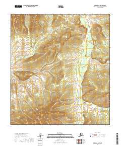
2019 Map of Medfra B-6 NW
USGS Topo · Published 2019About this map
Fossil Mtn rises above a wilderness landscape dominated by the winding drainage systems of the interior. The northern reaches of this territory are defined by the Susulatna River, which is joined further south by the Agate Fork Susulatna River. These waterways, along with smaller tributaries like Butte Cr and Canyon Cr, dictate the topography of the region, carving through the high ground that characterizes the Yukon-Koyukuk Census Area. This 2019 survey reflects a landscape largely shaped by its natural hydrology, with no modern infrastructure or permanent settlements indicated. The presence of Fossil Mtn suggests a geological point of interest in an otherwise remote stretch of Alaskan river country, providing a clear reference point for those studying the physical geography or navigating the intricate forks of the Susulatna system.
Find a feature on this map
9 named features on this map. Tap any name to fly to it.
Don’t see what you’re looking for? This feature index may not catch every label — zoom into the map to look around manually.
Map Details
Editions of this 2019 Medfra B-6 NW Map
This is the sole edition of this map. No revisions or reprints were ever made.
Other maps of this area

1950 · Medfra
USGS Topo · 1:250,000

1951 · Ophir
USGS Topo · 1:250,000

1954 · Medfra C-6
USGS Topo · 1:63,360

1954 · Medfra B-6
USGS Topo · 1:63,360

1954 · Ophir C-1
USGS Topo · 1:63,360

1954 · Ophir B-1
USGS Topo · 1:63,360

1954 · Ophir
USGS Topo · 1:250,000

1959 · Medfra
USGS Topo · 1:250,000
2019 · Medfra C-6 SW
USGS Topo · 1:25,000
2019 · Ophir B-1 NE
USGS Topo · 1:25,000