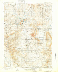
1908 Map of Medicine Bow
USGS Topo · Published 1932About this map
The Medicine Bow Range dominates this high-altitude landscape during the early twentieth century, showing a region defined by ranching, resource extraction, and early rail development. Surveyed between 1904 and 1906, the map documents the Laramie Hanns Peak and Pacific R R cutting across the foothills east of Centennial Ridge. Scattered ranching outposts such as the Logan-Grisley Ranch, Stillson Ranch, and Beckwith Ranch are established along the drainage of the Little Laramie River and its tributaries. Industrial footprints are visible at the White Swan Mine, American Mine, and Webbers Sawmill, illustrating the era's reliance on the mountain's timber and minerals. High-country landmarks like Medicine Bow Peak and Browns Peak tower over numerous alpine water bodies, including Lake Marie, Trout Lake, and Lake Owens. This survey captures the transition from a wilderness frontier to a more organized mountain economy just after the turn of the century.
Find a feature on this map
79 named features on this map. Tap any name to fly to it.
Don’t see what you’re looking for? This feature index may not catch every label — zoom into the map to look around manually.
Map Details
Editions of this 1908 Medicine Bow Map
3 editions found
Other maps of this area

1893 · Fort Steele
USGS Topo · 1:125,000

1895 · Laramie
USGS Topo · 1:125,000

1902 · Laramie
USGS Topo · 1:125,000

1905 · Laramie
USGS Topo · 1:125,000

1906 · Medicine Bow
USGS Topo · 1:125,000

1906 · Laramie
USGS Topo · 1:125,000

1908 · Laramie
USGS Topo · 1:125,000

1908 · Medicine Bow
USGS Topo · 1:125,000

1911 · Hahns Peak
USGS Topo · 1:125,000

1913 · Hahns Peak
USGS Topo · 1:125,000