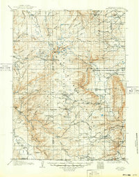
1908 Map of Medicine Bow
USGS Topo · Published 1949About this map
Medicine Bow Peak serves as the focal point of this early 20th-century survey, towering over the high-elevation terrain of the Medicine Bow Range and Medicine Bow Mountains. The landscape is a network of alpine lakes and headwaters, including Sand Lake, Lake Marie, and the three forks of the Rock Creek. The industrial and agricultural development of the era is evident through a scattered presence of family-run operations and extraction sites, such as Logan-Grisley Ranch, Stillson Ranch, and the American Mine.
Find a feature on this map
106 named features on this map. Tap any name to fly to it.
Don’t see what you’re looking for? This feature index may not catch every label — zoom into the map to look around manually.
Map Details
Editions of this 1908 Medicine Bow Map
3 editions found
Other maps of this area

1893 · Fort Steele
USGS Topo · 1:125,000

1895 · Laramie
USGS Topo · 1:125,000

1902 · Laramie
USGS Topo · 1:125,000

1905 · Laramie
USGS Topo · 1:125,000

1906 · Medicine Bow
USGS Topo · 1:125,000

1906 · Laramie
USGS Topo · 1:125,000

1908 · Laramie
USGS Topo · 1:125,000

1908 · Medicine Bow
USGS Topo · 1:125,000

1911 · Hahns Peak
USGS Topo · 1:125,000

1913 · Hahns Peak
USGS Topo · 1:125,000