
1968 Map of Medicine Butte
USGS Topo · Published 1969About this map
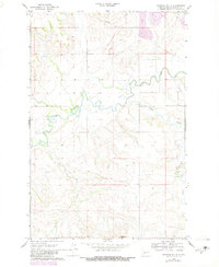
Medicine Butte dominates the southern portion of this Mercer County landscape as it was documented in the late 1960s. The meandering course of the Knife River winds through the central portion of the quadrangle, serving as a primary drainage for the surrounding prairie. To the north, early industrial activity is evident through the presence of a Strip Mine and scattered Gravel Pits, signaling the region's extraction-based economy. The map also captures a significant utility corridor marked by a Pipeline stretching across the northern sections. This survey provides a clear view of the natural hydrology of the area, featuring the junctions of Mud Creek and Coyote Creek as they feed into the larger river system, which remained largely undeveloped at the time of the field check.
Find a feature on this map
7 named features on this map. Tap any name to fly to it.
Don’t see what you’re looking for? This feature index may not catch every label — zoom into the map to look around manually.
Map Details
Editions of this 1968 Medicine Butte Map
2 editions found
Other maps of this area

1953 · Watford City
USGS Topo · 1:250,000

1954 · McClusky
USGS Topo · 1:250,000

1957 · Watford City
USGS Topo · 1:250,000

1958 · McClusky
USGS Topo · 1:250,000

1967 · Watford City
USGS Topo · 1:250,000

1968 · Beulah
USGS Topo · 1:24,000

1968 · Medicine Butte NE
USGS Topo · 1:24,000

1969 · Zap
USGS Topo · 1:24,000
1972 · Medicine Butte SW
USGS Topo · 1:24,000
1972 · Medicine Butte SE
USGS Topo · 1:24,000