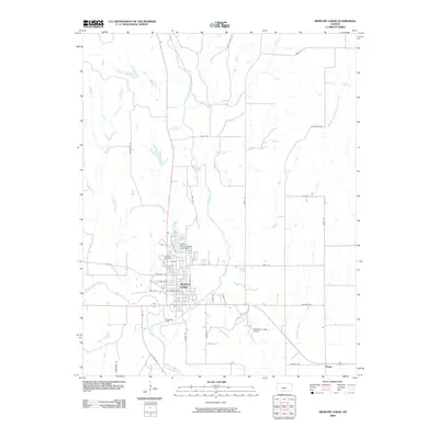
2009 Map of Medicine Lodge
USGS Topo · Published 2009About this map
Medicine Lodge serves as the central hub of this 2009 survey, situated at the confluence of the Medicine Lodge River and Elm Creek. The town's grid is clearly defined, featuring arterial roads like W Kansas Ave and Mill Rd, leading south toward the Bloom Oil Field. To the north, the Barber County State Lake Dam holds the waters of Barber County State Lake, a prominent recreational feature for the region.
Find a feature on this map
39 named features on this map. Tap any name to fly to it.
Don’t see what you’re looking for? This feature index may not catch every label — zoom into the map to look around manually.
Map Details
Editions of this 2009 Medicine Lodge Map
This is the sole edition of this map. No revisions or reprints were ever made.
Other maps of this area

1889 · Anthony
USGS Topo · 1:125,000

1891 · Medicine Lodge
USGS Topo · 1:125,000

1891 · Anthony
USGS Topo · 1:125,000

1893 · Medicine Lodge
USGS Topo · 1:125,000

1955 · Pratt
USGS Topo · 1:250,000

1959 · Pratt
USGS Topo · 1:250,000

1972 · Sharon South
USGS Topo · 1:24,000

1973 · Hardtner NW
USGS Topo · 1:24,000
1973 · Isabel
USGS Topo · 1:24,000
1973 · Gerlane
USGS Topo · 1:24,000