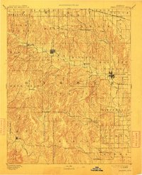
1893 Map of Medicine Lodge
USGS Topo · Published 1912About this map
The Medicine Lodge River carves a path through the heart of Barber County, defining the settlement patterns of this 1890 survey. At the crossing of major drainage systems, Medicine Lodge serves as the central hub, supported by the reach of the Atchison Topeka and Santa Fe Railroad which skirts the northeastern and eastern edges of the sheet. The landscape is characterized by a dense network of watercourses, from Big Mule Creek in the southwest to the headwaters of Elm Mills in the north, showing how early ranching and farming communities were bound to these vital creek valleys.
Find a feature on this map
70 named features on this map. Tap any name to fly to it.
Don’t see what you’re looking for? This feature index may not catch every label — zoom into the map to look around manually.
Map Details
Editions of this 1893 Medicine Lodge Map
5 editions found

Other maps of this area

1889 · Anthony
USGS Topo · 1:125,000

1889 · Kinsley
USGS Topo · 1:125,000

1891 · Medicine Lodge
USGS Topo · 1:125,000

1891 · Anthony
USGS Topo · 1:125,000

1892 · Kinsley
USGS Topo · 1:125,000

1892 · Kingman
USGS Topo · 1:125,000

1892 · Coldwater
USGS Topo · 1:125,000

1892 · Pratt
USGS Topo · 1:125,000

1893 · Medicine Lodge
USGS Topo · 1:125,000

1894 · Kinsley
USGS Topo · 1:125,000