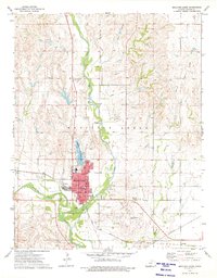
1973 Map of Medicine Lodge
USGS Topo · Published 1975About this map
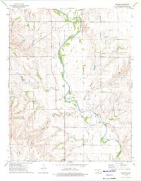
The Medicine Lodge River meanders across the southern plains of Barber County, defining the geography of a region shaped by both agriculture and the petroleum industry. During the mid-1970s, Medicine Lodge serves as the central hub, anchored by civic institutions like the Courthouse and City Hall, while its spiritual and educational life is centered at the High Sch and Highland Cem. The landscape reflects a diverse economy, from the heavy infrastructure of the Atchison Topeka and Santa Fe railroad to the active extraction at the Bloom Oil Field and various Gravel Pits. Local recreation and transit are well-established, evidenced by the Barber County State Lake to the north and the Medicine Lodge Airport to the southeast. Unique cultural landmarks like the Drive-in Theater and Golf Course illustrate the community's mid-century development patterns during this era of Kansas history.
Find a feature on this map
29 named features on this map. Tap any name to fly to it.
Don’t see what you’re looking for? This feature index may not catch every label — zoom into the map to look around manually.
Map Details
Editions of this 1973 Medicine Lodge Map
This is the sole edition of this map. No revisions or reprints were ever made.
Other maps of this area

1889 · Anthony
USGS Topo · 1:125,000

1891 · Medicine Lodge
USGS Topo · 1:125,000

1891 · Anthony
USGS Topo · 1:125,000

1893 · Medicine Lodge
USGS Topo · 1:125,000

1955 · Pratt
USGS Topo · 1:250,000

1959 · Pratt
USGS Topo · 1:250,000
1972 · Sharon South
USGS Topo · 1:24,000
1973 · Hardtner NW
USGS Topo · 1:24,000
1973 · Isabel
USGS Topo · 1:24,000
1973 · Gerlane
USGS Topo · 1:24,000