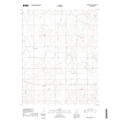
2018 Map of Medicine Lodge SW
USGS Topo · Published 2018About this map
Forest City stands as a primary point of reference in this corner of Barber County, where the winding course of the Medicine Lodge River carves through the central terrain. The landscape is defined by the striking topography of the Gypsum Hills in the northeast and the distinctive Twin Peaks to the south. This region is a study in Western Kansas drainage patterns, with numerous tributaries such as Bitter Cr, Cedar Cr, and Walnut Cr feeding into the main river valley. A network of rural section roads, including Mingona Rd and Twin Peaks Rd, grid the territory, providing access to the high ridges and cattle country. The map's detail reveals the intersection of natural erosion and human transit, tracing how historical routes like River Rd follow the natural contours of the river bottom below the rising red mesas.
Find a feature on this map
28 named features on this map. Tap any name to fly to it.
Don’t see what you’re looking for? This feature index may not catch every label — zoom into the map to look around manually.
Map Details
Editions of this 2018 Medicine Lodge SW Map
This is the sole edition of this map. No revisions or reprints were ever made.
Other maps of this area

1891 · Medicine Lodge
USGS Topo · 1:125,000

1893 · Medicine Lodge
USGS Topo · 1:125,000

1955 · Pratt
USGS Topo · 1:250,000

1959 · Pratt
USGS Topo · 1:250,000

1973 · Hardtner NW
USGS Topo · 1:24,000
1973 · Sun City NE
USGS Topo · 1:24,000
1973 · Isabel
USGS Topo · 1:24,000
1973 · Pump Creek
USGS Topo · 1:24,000
1973 · Lake City
USGS Topo · 1:24,000
1973 · Gerlane
USGS Topo · 1:24,000