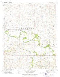
1973 Map of Medicine Lodge SW
USGS Topo · Published 1975About this map
The Medicine Lodge River carves a broad valley through the center of this Barber County landscape, defining the layout of rural industry and transport during the early 1970s. The Atchison Topeka and Santa Fe railroad tracks parallel the river's path, serving the small community of Mingona. To the west, the settlement of Forest City is marked by its proximity to a local Cem and the winding course of Bitter Creek. This survey highlights the region's reliance on mineral resources, as evidenced by a sprawling Oil and Gas Field in the southeast and numerous Gas Wells and Oil Wells peppered across the townships. Prominent landmarks like Twin Peaks provide vertical relief in an area otherwise dominated by the hydrological network of Cedar Creek and Walnut Creek.
Find a feature on this map
19 named features on this map. Tap any name to fly to it.
Don’t see what you’re looking for? This feature index may not catch every label — zoom into the map to look around manually.
Map Details
Editions of this 1973 Medicine Lodge SW Map
This is the sole edition of this map. No revisions or reprints were ever made.
Other maps of this area

1891 · Medicine Lodge
USGS Topo · 1:125,000

1893 · Medicine Lodge
USGS Topo · 1:125,000

1955 · Pratt
USGS Topo · 1:250,000

1959 · Pratt
USGS Topo · 1:250,000

1973 · Hardtner NW
USGS Topo · 1:24,000
1973 · Sun City NE
USGS Topo · 1:24,000
1973 · Isabel
USGS Topo · 1:24,000
1973 · Pump Creek
USGS Topo · 1:24,000
1973 · Lake City
USGS Topo · 1:24,000
1973 · Gerlane
USGS Topo · 1:24,000