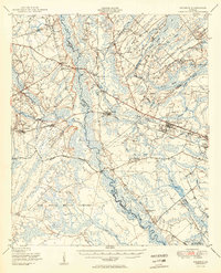
1950 Map of Meldrim
USGS Topo · Published 1950About this map
The Ogeechee River and Little Ogeechee River define the watery landscape of this coastal Georgia region at mid-century. The Central of Georgia and Seaboard Air Line railroads intersect at Meldrim, forming a critical transport hub for the local timber and agricultural economy. The southeastern portion of the map is dominated by the sprawling Camp Stewart Military Reservation, which occupies a significant portion of the terrain south of the Military Reservation Boundary.
Find a feature on this map
71 named features on this map. Tap any name to fly to it.
Don’t see what you’re looking for? This feature index may not catch every label — zoom into the map to look around manually.
Map Details
Editions of this 1950 Meldrim Map
2 editions found
Other maps of this area

1918 · Hinesville
USGS Topo · 1:62,500

1919 · Egypt
USGS Topo · 1:62,500

1920 · Hardeeville
USGS Topo · 1:62,500

1920 · Pembroke
USGS Topo · 1:62,500

1920 · Meldrim
USGS Topo · 1:62,500

1920 · Limerick
USGS Topo · 1:62,500

1921 · Brooklet
USGS Topo · 1:62,500

1939 · Egypt
USGS Topo · 1:62,500

1942 · Meldrim
USGS Topo · 1:62,500

1942 · Savannah
USGS Topo · 1:62,500