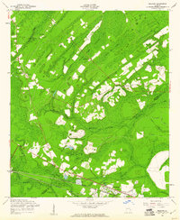
1958 Map of Meldrim
USGS Topo · Published 1961About this map
The lowlands of the Effingham and Chatham county line are defined by the convergence of the Ogeechee River and a vast network of wetlands in the late 1950s. The settlement at Meldrim serves as a junction point where the Central of Georgia and Seaboard Air Line railroads run parallel across the southern reach of the map. This rail-dependent landscape is dotted with small rural landmarks, including the Marlow Sch and numerous community meeting points like Union Ch and Bethesda Ch. North of the tracks, the terrain is dominated by expansive swamp systems such as Walthour Swamp and Horning Swamp, reflecting the hydrologic complexity of the coastal plain. In the southeast, Bloomingdale sits near the Pipe Makers Canal, while isolated features like the Artesian Well and Gravel Hill Cem provide specific points of interest for local history researchers.
Find a feature on this map
35 named features on this map. Tap any name to fly to it.
Don’t see what you’re looking for? This feature index may not catch every label — zoom into the map to look around manually.
Map Details
Editions of this 1958 Meldrim Map
4 editions found
Other maps of this area

1919 · Egypt
USGS Topo · 1:62,500

1920 · Hardeeville
USGS Topo · 1:62,500

1920 · Meldrim
USGS Topo · 1:62,500

1939 · Egypt
USGS Topo · 1:62,500

1942 · Meldrim
USGS Topo · 1:62,500

1942 · Savannah
USGS Topo · 1:62,500

1943 · Hardeeville
USGS Topo · 1:62,500

1943 · Egypt
USGS Topo · 1:62,500

1947 · Savannah
USGS Topo · 1:250,000

1948 · Savannah
USGS Topo · 1:250,000