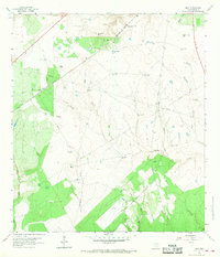
1962 Map of Melo
USGS Topo · Published 1968About this map
Windmills and ranching infrastructure define this corner of Goliad County in the early 1960s, where the Southern Pacific railroad cuts through a landscape of rolling coastal prairie. The small community of Melo and the nearby Melo Ranch serve as central points in a territory heavily shaped by water access, evidenced by the numerous named wells such as Spangle Windmill, Brahman Windmill, and the specialized Airfield Windmill. Family-named operations like Bissett Ranch and Clip Ranch illustrate the localized land ownership patterns of the era. To the south, the Sarco Cem remains a primary genealogical landmark near the banks of Sarco Creek. The map also captures the burgeoning energy industry of the Texas coast, with several Gas Wells and a major Pipeline traversing the drainages of Martinez Creek and Keys Hollow, highlighting the shift from traditional cattle ranching toward mineral extraction.
Find a feature on this map
38 named features on this map. Tap any name to fly to it.
Don’t see what you’re looking for? This feature index may not catch every label — zoom into the map to look around manually.
Map Details
Editions of this 1962 Melo Map
3 editions found
Other maps of this area

1953 · Beeville
USGS Topo · 1:250,000

1954 · Skidmore
USGS Topo · 1:62,500

1954 · Refugio
USGS Topo · 1:62,500

1956 · Beeville
USGS Topo · 1:250,000

1960 · Beeville
USGS Topo · 1:250,000

1962 · Live Oak Lake
USGS Topo · 1:24,000

1962 · Melo
USGS Topo · 1:24,000

1962 · Hensley Lake
USGS Topo · 1:24,000

1962 · Goliad
USGS Topo · 1:24,000

1963 · Berclair
USGS Topo · 1:24,000