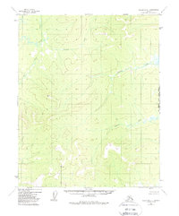
1952 Map of Melozitna D-1
USGS Topo · Published 1988About this map
Indian River flows through the northwestern corner of this remote Alaskan interior, marking a landscape defined by an intricate network of waterways including Big Creek and Sithdontit Creek. Photogrammetric methods from 1952 aerial surveys reveal a wilderness largely devoid of permanent settlements, instead punctuated by high-altitude survey markers such as VABM 1840 Trail and VABM 1941 Hunter. The presence of the label Calamity near the headwaters of a southern tributary to the main river suggests an area of local significance, perhaps tied to a specific historical event or difficult crossing known to early travelers. The map also delineates the precise boundary between the Kateel River Meridian and the Fairbanks Meridian, a critical detail for understanding the land survey history of the Yukon-Koyukuk region. A solitary Trail provides the only evidence of overland passage through these drainage basins of the Tobatokh Creek system.
Find a feature on this map
9 named features on this map. Tap any name to fly to it.
Don’t see what you’re looking for? This feature index may not catch every label — zoom into the map to look around manually.
Map Details
Editions of this 1952 Melozitna D-1 Map
4 editions found
Other maps of this area

1951 · Hughes
USGS Topo · 1:250,000

1951 · Melozitna
USGS Topo · 1:250,000

1951 · Bettles
USGS Topo · 1:250,000

1951 · Tanana
USGS Topo · 1:250,000

1952 · Melozitna D-1
USGS Topo · 1:63,360

1955 · Melozitna D-2
USGS Topo · 1:63,360

1955 · Hughes A-2
USGS Topo · 1:63,360

1955 · Hughes A-1
USGS Topo · 1:63,360

1956 · Hughes
USGS Topo · 1:250,000

1956 · Bettles
USGS Topo · 1:250,000