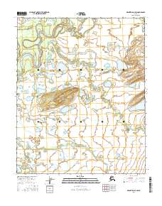
2016 Map of Melozitna D-3 SW
USGS Topo · Published 2016About this map
The Indian River winds across this interior Alaskan landscape, defining a complex riparian environment marked by seasonal water shifts and sediment movement. Within the northern reaches of the quadrangle, Mathews Slough serves as a secondary channel, while the meandering course of the Little Indian River cuts through the central and southern terrain. These water systems reflect a dynamic wilderness largely defined by its drainage patterns rather than permanent settlements, with the map recording the precise township and range divisions such as t6n r21e and t5n r22e that grid the subarctic territory. The landscape appears as a mosaic of wetlands and fluctuating water levels typical of the Yukon-Koyukuk region, captured here just before the end of the second decade of the 2000s.
Find a feature on this map
9 named features on this map. Tap any name to fly to it.
Don’t see what you’re looking for? This feature index may not catch every label — zoom into the map to look around manually.
Map Details
Editions of this 2016 Melozitna D-3 SW Map
This is the sole edition of this map. No revisions or reprints were ever made.
Other maps of this area

1951 · Melozitna
USGS Topo · 1:250,000

1952 · Melozitna D-3
USGS Topo · 1:63,360

1954 · Melozitna C-4
USGS Topo · 1:63,360

1954 · Melozitna D-4
USGS Topo · 1:63,360

1954 · Melozitna C-3
USGS Topo · 1:63,360

1954 · Melozitna D-3
USGS Topo · 1:63,360

1956 · Melozitna
USGS Topo · 1:250,000
2016 · Melozitna D-4 SE
USGS Topo · 1:25,000
2016 · Melozitna D-3 SE
USGS Topo · 1:25,000
2016 · Melozitna D-3 NE
USGS Topo · 1:25,000