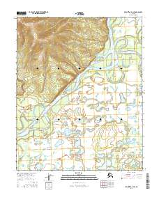
2016 Map of Melozitna D-4 SE
USGS Topo · Published 2016About this map
The Koyukuk River dominates this interior Alaskan landscape, carving a wide, braided path through the Yukon-Koyukuk region. In this 2016 survey, the river's dynamic nature is evident in the intricate network of side channels and wetlands, most notably Mathews Slough which meanders through the eastern floodplains. The terrain transitions from the high, relief-rich contours in the northwest down to a low-lying basin characterized by numerous small ponds and seasonal water bodies.
Find a feature on this map
10 named features on this map. Tap any name to fly to it.
Don’t see what you’re looking for? This feature index may not catch every label — zoom into the map to look around manually.
Map Details
Editions of this 2016 Melozitna D-4 SE Map
This is the sole edition of this map. No revisions or reprints were ever made.
Other maps of this area

1951 · Melozitna
USGS Topo · 1:250,000

1952 · Melozitna D-3
USGS Topo · 1:63,360

1954 · Melozitna C-4
USGS Topo · 1:63,360

1954 · Melozitna D-4
USGS Topo · 1:63,360

1954 · Melozitna C-3
USGS Topo · 1:63,360

1954 · Melozitna D-3
USGS Topo · 1:63,360

1956 · Melozitna
USGS Topo · 1:250,000
2016 · Melozitna D-3 NW
USGS Topo · 1:25,000
2016 · Melozitna D-4 NE
USGS Topo · 1:25,000
2016 · Melozitna D-4 NW
USGS Topo · 1:25,000