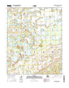
2016 Map of Melozitna D-6 SW
USGS Topo · Published 2016About this map
Nododehon Lake lies at the heart of this Alaskan interior landscape, a region defined by an intricate network of wetlands and seasonal water bodies. The terrain is dominated by the Dulbi Flats, an expanse where the natural drainage of the land creates a complex pattern of ponds and marshes. The Nogoyalna Slough meanders along the northern edge of the map, illustrating the slow, shifting hydrology of the Yukon-Koyukuk region. In this part of the Melozitna drainage, the absence of roads or permanent settlements in 2016 highlights the isolated character of the subarctic wilderness. The map serves as a detailed record of water distribution and land survey boundaries, including t5n r14e and t6n r15e, which are essential for navigating and managing this remote environment.
Find a feature on this map
9 named features on this map. Tap any name to fly to it.
Don’t see what you’re looking for? This feature index may not catch every label — zoom into the map to look around manually.
Map Details
Editions of this 2016 Melozitna D-6 SW Map
This is the sole edition of this map. No revisions or reprints were ever made.
Other maps of this area

1951 · Kateel River
USGS Topo · 1:250,000

1951 · Melozitna
USGS Topo · 1:250,000

1954 · Melozitna C-6
USGS Topo · 1:63,360

1954 · Kateel River C-1
USGS Topo · 1:63,360

1954 · Kateel River D-1
USGS Topo · 1:63,360

1954 · Melozitna D-6
USGS Topo · 1:63,360

1955 · Kateel River
USGS Topo · 1:250,000

1956 · Melozitna
USGS Topo · 1:250,000
2016 · Kateel River C-1 NE
USGS Topo · 1:25,000
2016 · Kateel River D-1 SE
USGS Topo · 1:25,000