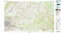
1986 Map of Memphis East
USGS Topo · Published 1986About this map
The Hatchie River and its expansive Hatchie Bottom wetlands dominate the northeastern corridor of this 1986 survey, reflecting a landscape defined by significant river drainage systems including the Loosahatchie River and the Wolf River. While the eastern suburbs of Memphis, such as Bartlett and Germantown, show the patterns of late-twentieth-century residential expansion, the surrounding areas maintain a distinct institutional and agricultural character. Notable facilities like the U S Naval Air Station and the Western Mental Health Institute stand alongside large conservation tracts including the Hatchie National Wildlife Refuge. The map captures the region's rail-reliant history, showing the routes of the Illinois Central Gulf RR and Southern Ry as they connect smaller outlying settlements like Somerville, Grand Junction, and Moscow. Local genealogy is well-supported by numerous named rural landmarks, such as Salem Church and Memory Hill Gardens.
Find a feature on this map
134 named features on this map. Tap any name to fly to it.
Don’t see what you’re looking for? This feature index may not catch every label — zoom into the map to look around manually.
Map Details
Editions of this 1986 Memphis East Map
2 editions found
Other maps of this area

1916 · Memphis
USGS Topo · 1:62,500

1925 · Memphis
USGS Topo · 1:48,000

1927 · Memphis
USGS Topo · 1:62,500

1931 · Jericho
USGS Topo · 1:62,500

1932 · Horn Lake
USGS Topo · 1:48,000

1935 · Horn Lake
USGS Topo · 1:62,500

1939 · Jericho
USGS Topo · 1:62,500

1939 · Memphis
USGS Topo · 1:62,500

1939 · Evadale
USGS Topo · 1:62,500

1942 · Millington
USGS Topo · 1:62,500