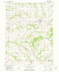
1981 Map of Mendon
USGS Topo · Published 1981About this map
Mendon serves as a central hub in northern Adams County, where the Burlington Northern rail line cuts across the landscape toward Fowler. This 1981 survey details a highly settled agricultural region defined by a dense network of family and community burial grounds, including Franklin Cem, Keith Cem, and New Providence Cem. The terrain is deeply etched by watercourses such as Grindstone Creek, Rock Creek, and Baldwin Creek, which create a complex pattern of drainage through the townships of Ursa, Keene, and Honey Creek.
Find a feature on this map
42 named features on this map. Tap any name to fly to it.
Don’t see what you’re looking for? This feature index may not catch every label — zoom into the map to look around manually.
Map Details
Editions of this 1981 Mendon Map
This is the sole edition of this map. No revisions or reprints were ever made.
Other maps of this area

1925 · Quincy
USGS Topo · 1:62,500

1925 · Liberty
USGS Topo · 1:62,500

1927 · Liberty
USGS Topo · 1:62,500

1944 · Quincy
USGS Topo · 1:62,500

1945 · Quincy
USGS Topo · 1:62,500

1946 · Mendon
USGS Topo · 1:62,500

1948 · Quincy
USGS Topo · 1:250,000

1948 · Mendon
USGS Topo · 1:62,500

1948 · Camp Point
USGS Topo · 1:62,500

1956 · Quincy
USGS Topo · 1:250,000