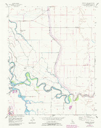
1956 Map of Mendota Dam
USGS Topo · Published 1984About this map
The San Joaquin River and a complex network of man-made waterways define the landscape of this Central Valley region during the mid-20th century. At the heart of this irrigation and water management system sits the Mendota Dam, regulating flow into the Mendota Pool. The map illustrates a transitional period for the area, where the vast agricultural holdings of the New Columbia Ranch, Pomona Ranch, and Aliso Ranch coexist with emerging energy infrastructure, evidenced by scattered Gas Wells to the east. Extensive engineering is visible through the prominent Chowchilla Canal and Delta-Mendota Canal, which cut across the natural meanders of the river and Fresno Slough. The city of Mendota appears at the southern edge, serving as a hub for this intersection of water, ranching, and industrial development.
Find a feature on this map
24 named features on this map. Tap any name to fly to it.
Don’t see what you’re looking for? This feature index may not catch every label — zoom into the map to look around manually.
Map Details
Editions of this 1956 Mendota Dam Map
3 editions found
Other maps of this area

1920 · Bonita Ranch
USGS Topo · 1:31,680

1921 · Mendota
USGS Topo · 1:31,680

1921 · Bonita Ranch
USGS Topo · 1:31,680

1922 · Tufts Ranch
USGS Topo · 1:31,680

1922 · Pozo Farm
USGS Topo · 1:31,680

1922 · Kentucky Well
USGS Topo · 1:31,680

1923 · Firebaugh
USGS Topo · 1:31,680

1924 · Jamesan
USGS Topo · 1:31,680

1924 · Tranquillity
USGS Topo · 1:31,680

1924 · Gravelly Ford
USGS Topo · 1:31,680