
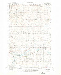
1951 Map of Menoken
USGS Topo · Published 1952About this map
Apple Creek meanders across this Burleigh County landscape, serving as a central geographical feature for a region defined by its rural townships and early mid-century infrastructure. The Northern Pacific railroad cuts through the southern half of the quadrangle, anchoring the settlement of Menoken (Burleigh Sta). To the west, the presence of the State Penitentiary and the Bismarck Municipal Airport marks the transition into the outskirts of the state capital.
Find a feature on this map
33 named features on this map. Tap any name to fly to it.
Don’t see what you’re looking for? This feature index may not catch every label — zoom into the map to look around manually.
Map Details
Editions of this 1951 Menoken Map
2 editions found
Other maps of this area

1907 · Bismarck
USGS Topo · 1:125,000

1950 · Wilton
USGS Topo · 1:62,500

1950 · Bismarck
USGS Topo · 1:24,000

1951 · Menoken SW
USGS Topo · 1:24,000

1951 · Bismarck
USGS Topo · 1:62,500

1951 · McKenzie
USGS Topo · 1:62,500

1954 · Bismarck
USGS Topo · 1:250,000

1954 · McClusky
USGS Topo · 1:250,000

1958 · Bismarck
USGS Topo · 1:250,000

1958 · McClusky
USGS Topo · 1:250,000