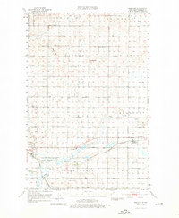
1951 Map of Menoken
USGS Topo · Published 1976About this map
Apple Creek meanders through this agricultural landscape east of Bismarck, where the rail-and-road network of the early 1950s defined local commerce. The village of Menoken (Burleigh Sta) serves as a primary hub along the Northern Pacific railroad, while the Minneapolis St Paul and Sault Ste Marie line cuts through the southern townships. The map reveals a high density of rural institutions, including St Hildegard Ch and numerous numbered schoolhouses like School No 1 and Gibbs Sch. Rising above the prairie, Keever Butte and Solberg Butte provide topographical relief, while the Radio Tower (KFYR) and a Radio Range Station mark the era's growing communication infrastructure. This survey preserves the mid-century layout of townships such as Naughton and Gibbs before modern suburban expansion altered the prairie's character.
Find a feature on this map
24 named features on this map. Tap any name to fly to it.
Don’t see what you’re looking for? This feature index may not catch every label — zoom into the map to look around manually.
Map Details
Editions of this 1951 Menoken Map
2 editions found
Other maps of this area

1907 · Bismarck
USGS Topo · 1:125,000

1950 · Wilton
USGS Topo · 1:62,500

1950 · Bismarck
USGS Topo · 1:24,000

1951 · Menoken SW
USGS Topo · 1:24,000

1951 · Bismarck
USGS Topo · 1:62,500

1951 · Menoken
USGS Topo · 1:62,500

1951 · McKenzie
USGS Topo · 1:62,500

1954 · Bismarck
USGS Topo · 1:250,000

1954 · McClusky
USGS Topo · 1:250,000

1958 · Bismarck
USGS Topo · 1:250,000