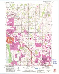
1958 Map of Menomonee Falls
USGS Topo · Published 1994About this map
Tamarack Swamp defines the lower-left landscape of this mid-century survey, a natural break in the suburban expansion occurring between Milwaukee and Germantown. The map records a critical era of regional transition, where old crossroads settlements like Fussville and West Granville are increasingly interconnected by a network of arterial roads including Good Hope Road and Brown Deer Road.
Find a feature on this map
47 named features on this map. Tap any name to fly to it.
Don’t see what you’re looking for? This feature index may not catch every label — zoom into the map to look around manually.
Map Details
Editions of this 1958 Menomonee Falls Map
4 editions found
Other maps of this area

1892 · Milwaukee
USGS Topo · 1:62,500

1892 · Waukesha
USGS Topo · 1:62,500

1892 · Port Washington
USGS Topo · 1:62,500

1901 · Milwaukee
USGS Topo · 1:62,500

1901 · Waukesha
USGS Topo · 1:62,500

1904 · West Bend
USGS Topo · 1:62,500

1904 · Port Washington
USGS Topo · 1:62,500

1906 · Waukesha
USGS Topo · 1:62,500

1906 · Milwaukee
USGS Topo · 1:62,500

1954 · Milwaukee
USGS Topo · 1:250,000