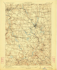
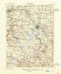
1913 Map of Mercer
USGS Topo · Published 1923About this map
Mercer and Grove City anchor this Western Pennsylvania landscape, serving as the commercial and educational hubs for a region defined by its rural crossroads and developing industry. The presence of the Slippery Rock State Normal School in the southeast and the State Hospital near the county seat highlights the area's institutional significance just before the First World War. Local commerce is shaped by the intersection of the Pennsylvania RR and the Bessemer and Lake Erie RR, which served coal operations like Number Five Mine and early petroleum infrastructure such as the Oil Pumping Sta. Numerous family-named schools, including Cribbs School and Boston School, are scattered across the townships of Findley and Wolf Creek, marking the small community centers of a pre-motorized era. The drainage of Wolf Creek and Slippery Rock Creek creates a complex network of runs and swamps that dictated the placement of early settlements like Pardoe and Amsterdam.
Find a feature on this map
135 named features on this map. Tap any name to fly to it.
Don’t see what you’re looking for? This feature index may not catch every label — zoom into the map to look around manually.
Map Details
Editions of this 1913 Mercer Map
6 editions found

Other maps of this area

1902 · New Castle
USGS Topo · 1:62,500

1904 · Newcastle
USGS Topo · 1:62,500

1905 · Neshannock
USGS Topo · 1:62,500

1907 · Neshannock
USGS Topo · 1:62,500

1908 · Shenango
USGS Topo · 1:62,500

1908 · Zelienople
USGS Topo · 1:62,500

1909 · Franklin
USGS Topo · 1:62,500

1909 · Butler
USGS Topo · 1:62,500

1910 · Zelienople
USGS Topo · 1:62,500

1910 · Hilliards
USGS Topo · 1:62,500