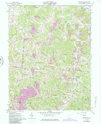
1961 Map of Mercerville
USGS Topo · Published 1985About this map
The boundary of the Wayne National Forest bisects this portion of Gallia County, where the landscape is defined by the winding drainages of Raccoon Creek and Indian Guyan Creek. In the early 1960s, this rural area was characterized by a dense network of family-named cemeteries and small community anchors such as Bethesda Ch and Macedonia Ch. Notable for its many small-scale resource extraction sites, the map shows numerous Strip Mines appearing as purple photorevised additions, indicating increased mining activity by the mid-1980s.
Find a feature on this map
90 named features on this map. Tap any name to fly to it.
Don’t see what you’re looking for? This feature index may not catch every label — zoom into the map to look around manually.
Map Details
Editions of this 1961 Mercerville Map
4 editions found
Other maps of this area

1906 · Bidwell
USGS Topo · 1:62,500

1906 · Athalia
USGS Topo · 1:62,500

1906 · Glenwood
USGS Topo · 1:62,500

1908 · Bidwell
USGS Topo · 1:62,500

1908 · Athalia
USGS Topo · 1:62,500

1908 · Glenwood
USGS Topo · 1:62,500

1908 · Point Pleasant
USGS Topo · 1:62,500

1926 · Point Pleasant
USGS Topo · 1:62,500

1929 · Point Pleasant
USGS Topo · 1:62,500

1957 · Huntington
USGS Topo · 1:250,000