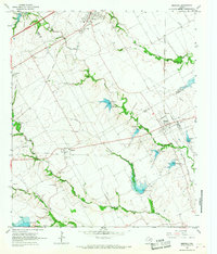
1965 Map of Mertens
USGS Topo · Published 1967About this map
Old Brandon Cem and the nearby Bynum-Brandon Cem anchor this 1960s landscape, serving as primary touchstones for family historians and genealogists in central Texas. The map illustrates a transitional rural economy where traditional agriculture meets modern water management, evidenced by a series of numbered dams such as Dam No 44 and Dam No 57 constructed along the drainage basins of Richland Creek and Cottonwood Creek. The settlement patterns are defined by the crossroads at Mertens and Brandon, where the infrastructure of the Missouri Kansas Texas and Missouri Pacific railroads once drove local commerce. Education is highlighted through specific sites like the High Sch and Kelly-Miller Sch in Milford, providing a clear view of the civic layout before decades of school consolidation altered the regional community structure.
Find a feature on this map
28 named features on this map. Tap any name to fly to it.
Don’t see what you’re looking for? This feature index may not catch every label — zoom into the map to look around manually.
Map Details
Editions of this 1965 Mertens Map
This is the sole edition of this map. No revisions or reprints were ever made.
Other maps of this area

1891 · Cleburne
USGS Topo · 1:125,000

1892 · Waco
USGS Topo · 1:125,000

1894 · Cleburne
USGS Topo · 1:125,000

1920 · Waco
USGS Topo · 1:125,000

1954 · Dallas
USGS Topo · 1:250,000

1954 · Waco
USGS Topo · 1:250,000

1955 · Waco
USGS Topo · 1:250,000

1956 · Abbott
USGS Topo · 1:24,000

1957 · Irene
USGS Topo · 1:24,000
1957 · Malone
USGS Topo · 1:24,000