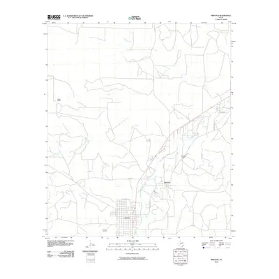
2010 Map of Mertzon
USGS Topo · Published 2010About this map
Mertzon and its neighbor Sherwood sit along the banks of Spring Creek in this West Texas survey. The map illustrates a landscape defined by intermittent watercourses like Bull Run Creek and Lopez Creek, which feed into the primary valley where the two settlements are clustered. For researchers, the layout of these towns is clearly defined, with the grid of Mertzon contrasting against the more dispersed rural character of Sherwood.
Find a feature on this map
23 named features on this map. Tap any name to fly to it.
Don’t see what you’re looking for? This feature index may not catch every label — zoom into the map to look around manually.
Map Details
Editions of this 2010 Mertzon Map
This is the sole edition of this map. No revisions or reprints were ever made.
Other maps of this area

1895 · Sherwood
USGS Topo · 1:125,000

1928 · Tankersly
USGS Topo · 1:62,500

1954 · San Angelo
USGS Topo · 1:250,000

1957 · Knickerbocker
USGS Topo · 1:62,500

1958 · San Angelo
USGS Topo · 1:250,000

1965 · San Angelo
USGS Topo · 1:250,000

1971 · Noelke
USGS Topo · 1:24,000

1972 · Arden
USGS Topo · 1:24,000
1972 · Hulldale NW
USGS Topo · 1:24,000
1972 · Noelke NE
USGS Topo · 1:24,000