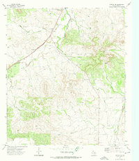
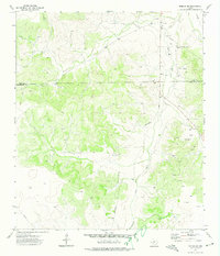
1972 Map of Noelke NE
USGS Topo · Published 1974About this map
Mertzon anchors the northern edge of this West Texas landscape, serving as a vital rail point along the Atchison Topeka and Santa Fe line in the early 1970s. The terrain is defined by dry draws and seasonal watercourses like Rock Pen Draw and Spring Creek, which reveal the arid character of Irion County. A series of natural springs and windmills scattered across the quadrangle suggest the critical importance of water management for local ranching and transit. Near the railroad, a Roadside Park and several Gravel Pit sites indicate the intersection of transportation infrastructure and local resource extraction. To the south, the map traces the winding path of Dove Creek and a major Pipeline, illustrating how industrial utility and natural topography shaped the region's development during this era.
Find a feature on this map
11 named features on this map. Tap any name to fly to it.
Don’t see what you’re looking for? This feature index may not catch every label — zoom into the map to look around manually.
Map Details
Editions of this 1972 Noelke NE Map
2 editions found
Other maps of this area

1895 · Sherwood
USGS Topo · 1:125,000

1928 · Tankersly
USGS Topo · 1:62,500

1954 · San Angelo
USGS Topo · 1:250,000

1957 · Knickerbocker
USGS Topo · 1:62,500

1958 · San Angelo
USGS Topo · 1:250,000

1965 · San Angelo
USGS Topo · 1:250,000

1971 · Noelke
USGS Topo · 1:24,000
1971 · Noelke SW
USGS Topo · 1:24,000
1972 · Hulldale NW
USGS Topo · 1:24,000
1972 · Noelke SE
USGS Topo · 1:24,000