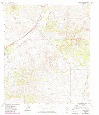
1972 Map of Noelke NE
USGS Topo · Published 1987About this map
Mertzon serves as the primary hub in this Irion County landscape, situated along the Atchison Topeka and Santa Fe railroad line. The terrain is defined by dry watercourses and seasonal drainage patterns, most notably Rock Pen Draw and Spring Creek, which reflect the arid ranching environment of West Texas. While the northern portion of the map shows concentrated activity near the tracks, the southern reaches toward Bolt are characterized by a network of ranch roads and scattered industrial markers.
Find a feature on this map
18 named features on this map. Tap any name to fly to it.
Don’t see what you’re looking for? This feature index may not catch every label — zoom into the map to look around manually.
Map Details
Editions of this 1972 Noelke NE Map
2 editions found
Other maps of this area

1895 · Sherwood
USGS Topo · 1:125,000

1928 · Tankersly
USGS Topo · 1:62,500

1954 · San Angelo
USGS Topo · 1:250,000

1957 · Knickerbocker
USGS Topo · 1:62,500

1958 · San Angelo
USGS Topo · 1:250,000

1965 · San Angelo
USGS Topo · 1:250,000

1971 · Noelke
USGS Topo · 1:24,000
1971 · Noelke SW
USGS Topo · 1:24,000
1972 · Hulldale NW
USGS Topo · 1:24,000
1972 · Noelke NE
USGS Topo · 1:24,000