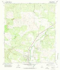
1972 Map of Mertzon
USGS Topo · Published 1974About this map
Mertzon and neighboring Sherwood serve as the primary hubs in this West Texas survey, where the Atchison Topeka and Santa Fe railroad corridor dictates the path of development. The landscape is defined by the drainage systems of Spring Creek and Lopez Creek, which carve through the high ground punctuated by the Lopez Peaks. A network of infrastructure, including a prominent Pipeline and the Arden Road, connects the rural ranching and industrial landscape.
Find a feature on this map
16 named features on this map. Tap any name to fly to it.
Don’t see what you’re looking for? This feature index may not catch every label — zoom into the map to look around manually.
Map Details
Editions of this 1972 Mertzon Map
2 editions found
Other maps of this area

1895 · Sherwood
USGS Topo · 1:125,000

1928 · Tankersly
USGS Topo · 1:62,500

1954 · San Angelo
USGS Topo · 1:250,000

1957 · Knickerbocker
USGS Topo · 1:62,500

1958 · San Angelo
USGS Topo · 1:250,000

1965 · San Angelo
USGS Topo · 1:250,000

1971 · Noelke
USGS Topo · 1:24,000

1972 · Arden
USGS Topo · 1:24,000
1972 · Hulldale NW
USGS Topo · 1:24,000
1972 · Noelke NE
USGS Topo · 1:24,000