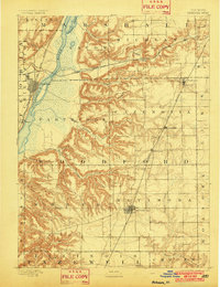
1893 Map of Metamora
USGS Topo · Published 1902About this map
Metamora serves as the focal point of this late-nineteenth-century landscape, positioned at a critical junction of the fertile Illinois prairie and the deeply dissected ravines leading toward the Illinois River. The map illustrates a transitional era of transportation, where the river's dominance is matched by a dense network of iron rails. Three major lines, including the Chicago and Alton Railroad and the Atchison Topeka and Santa Fe Railroad, cut through the terrain to connect small settlements like Low Point and Washburn to larger markets. Along the river, Chillicothe and Rome anchor the western bank, while the eastern bluffs are carved by dramatic drainages such as Richland Creek and Black Partridge Creek. For the researcher, the map reveals the precise grid of early rural life, highlighting isolated communities like Lourds and Germantown that were essential to the region's agricultural identity.
Find a feature on this map
35 named features on this map. Tap any name to fly to it.
Don’t see what you’re looking for? This feature index may not catch every label — zoom into the map to look around manually.
Map Details
Editions of this 1893 Metamora Map
4 editions found
Other maps of this area

1893 · Lacon
USGS Topo · 1:62,500

1893 · Metamora
USGS Topo · 1:62,500

1893 · Dunlap
USGS Topo · 1:62,500

1898 · Dunlap
USGS Topo · 1:62,500

1905 · Peoria
USGS Topo · 1:62,500

1927 · Peoria
USGS Topo · 1:62,500

1927 · Danvers
USGS Topo · 1:62,500

1928 · Mackinaw
USGS Topo · 1:62,500

1930 · Danvers
USGS Topo · 1:62,500

1932 · Mackinaw
USGS Topo · 1:62,500