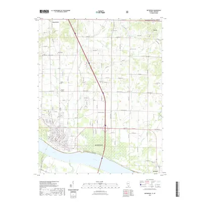
2021 Map of Metropolis
USGS Topo · Published 2021About this map
The Ohio River forms the southern boundary of this region, separating Metropolis, Illinois, from McCracken County, Kentucky. The city grid of Metropolis is clearly defined by its numbered streets, ranging from 1st St near the waterfront up to E 19th St. The surrounding Massac County landscape is a mix of agricultural plots and small drainage systems such as Massac Creek, Sevenmile Cr, and Weaver Cr. To the north, the terrain transitions into the protected woodlots of the Shawnee National Forest. This 2021 survey highlights an extensive network of local burial sites, including the Metropolis Memorial Gardens, Odd Fellows Cem, and the Masonic Cem, which are significant for genealogical research. Smaller outlying settlements like Round Knob and Midway are connected to the urban center by a lattice of rural roads such as Upper Salem Rd and Country Club Rd.
Find a feature on this map
139 named features on this map. Tap any name to fly to it.
Don’t see what you’re looking for? This feature index may not catch every label — zoom into the map to look around manually.
Map Details
Editions of this 2021 Metropolis Map
This is the sole edition of this map. No revisions or reprints were ever made.
Other maps of this area

1917 · Brownfield
USGS Topo · 1:62,500

1918 · Vienna
USGS Topo · 1:62,500

1919 · Vienna
USGS Topo · 1:62,500

1926 · Paducah
USGS Topo · 1:62,500

1928 · La Center
USGS Topo · 1:62,500

1929 · Paducah
USGS Topo · 1:62,500

1932 · La Center
USGS Topo · 1:62,500

1936 · Paducah
USGS Topo · 1:24,000

1940 · Paducah
USGS Topo · 1:62,500

1942 · Vienna
USGS Topo · 1:62,500