
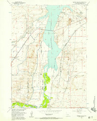
1951 Map of Mexican Pass SE
USGS Topo · Published 1951About this map
The Wind River Indian Reservation occupies the northern half of this mid-century survey, where the drainages of Cottonwood Creek and Muddy Creek define the arid landscape. The map captures a specific moment in the hydraulic development of the Missouri River Basin, most notably marking the Boysen Reservoir (Proposed) along the eastern edge before the land was inundated. This transition from open creek-beds to planned reservoir highlights the changing geography of Fremont County during the early 1950s. Across the center, the prominent Sand Mesa stands between two vital transit corridors: the Mexican Pass Road and the Muddy Creek Road. These routes, along with a noted Gaging Sta on the lower creek, represent the essential infrastructure of a region balancing traditional reservation land with new water reclamation projects.
Find a feature on this map
9 named features on this map. Tap any name to fly to it.
Don’t see what you’re looking for? This feature index may not catch every label — zoom into the map to look around manually.
Map Details
Editions of this 1951 Mexican Pass SE Map
This is the sole edition of this map. No revisions or reprints were ever made.
Other maps of this area

1950 · Mexican Pass SW
USGS Topo · 1:24,000

1950 · Bonneville SW
USGS Topo · 1:24,000

1951 · Boysen
USGS Topo · 1:24,000

1951 · Mexican Pass
USGS Topo · 1:24,000

1951 · Morrison Canyon
USGS Topo · 1:24,000

1951 · Hidden Valley
USGS Topo · 1:24,000

1952 · Riverton NE
USGS Topo · 1:24,000

1952 · Lost Wells Butte
USGS Topo · 1:24,000

1955 · Thermopolis
USGS Topo · 1:250,000
1957 · Hidden Valley
USGS Topo · 1:24,000