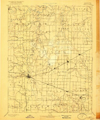
1890 Map of Mexico
USGS Topo · Published 1921About this map
The town of Mexico serves as the central hub of this late-nineteenth-century landscape, where a dense network of iron rails defines the local economy and movement. Surveyed in 1887, the map illustrates the critical intersections of the Wabash Railroad, the Chicago and Alton Railroad, and the Alton Railroad. These lines connect a series of small, burgeoning agricultural settlements like Benton City, Martinsburgh, Laddonia, and Rush Hill. Away from the rail corridors, the terrain is shaped by the winding branches of the Salt River and its numerous tributaries, including the Middle Fork of Salt River and the South Fork. Notable outliers like the northern settlement of Florida and the post office at Shamrock provide important markers for genealogists tracing ancestors in the rural reaches of Audrain and Monroe counties during this era of westward expansion.
Find a feature on this map
82 named features on this map. Tap any name to fly to it.
Don’t see what you’re looking for? This feature index may not catch every label — zoom into the map to look around manually.
Map Details
Editions of this 1890 Mexico Map
5 editions found
Other maps of this area

1886 · Jefferson City
USGS Topo · 1:125,000

1890 · Louisiana
USGS Topo · 1:125,000

1890 · Mexico
USGS Topo · 1:125,000

1890 · Moberly
USGS Topo · 1:125,000

1890 · Hermann
USGS Topo · 1:125,000

1890 · Fulton
USGS Topo · 1:125,000

1894 · Jefferson City
USGS Topo · 1:125,000

1903 · Palmyra
USGS Topo · 1:125,000

1928 · Fulton
USGS Topo · 1:62,500

1931 · Fulton
USGS Topo · 1:62,500