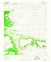
1956 Map of Miami
USGS Topo · Published 1968About this map
Philmont Scout Ranch Headquarters and the adjacent Camping Headquarters anchor the northern reaches of this mid-century survey, documenting the early development of this iconic landscape. The map centers on the Beaubien and Miranda Grant (Maxwell Grant), where the high mesas of Tooth of Time Ridge and Urraca Mesa meet the drainage of the Cimarron River. The settlement of Miami appears to the east, supported by an intricate network of irrigation ditches and the waters of Miami Lake.
Find a feature on this map
45 named features on this map. Tap any name to fly to it.
Don’t see what you’re looking for? This feature index may not catch every label — zoom into the map to look around manually.
Map Details
Editions of this 1956 Miami Map
4 editions found
Other maps of this area

1915 · Koehler
USGS Topo · 1:62,500

1917 · Koehler
USGS Topo · 1:62,500

1954 · Raton
USGS Topo · 1:250,000

1955 · Cimarron
USGS Topo · 1:62,500

1955 · Ute Park
USGS Topo · 1:62,500

1956 · Tooth Of Time
USGS Topo · 1:62,500

1956 · Miami
USGS Topo · 1:62,500

1958 · Raton
USGS Topo · 1:250,000

1964 · Colmor
USGS Topo · 1:24,000

1964 · Pinon Hills
USGS Topo · 1:24,000