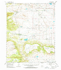
1956 Map of Miami
USGS Topo · Published 1978About this map
Philmont Scout Ranch serves as the focal point of this northern New Mexico landscape, centered on the Philmont Scout Ranch Headquarters and the Training Center in the mid-1950s. The map documents the intricate ranching and institutional geography of the Beaubien and Miranda (Maxwell Grant), where family-named outposts like Vallejo Ranch, Fernandez Ranch, and Mc Daniel Cimarron Place dot the high mesas.
Find a feature on this map
53 named features on this map. Tap any name to fly to it.
Don’t see what you’re looking for? This feature index may not catch every label — zoom into the map to look around manually.
Map Details
Editions of this 1956 Miami Map
4 editions found
Other maps of this area

1915 · Koehler
USGS Topo · 1:62,500

1917 · Koehler
USGS Topo · 1:62,500

1954 · Raton
USGS Topo · 1:250,000

1955 · Cimarron
USGS Topo · 1:62,500

1955 · Ute Park
USGS Topo · 1:62,500

1956 · Tooth Of Time
USGS Topo · 1:62,500

1956 · Miami
USGS Topo · 1:62,500

1958 · Raton
USGS Topo · 1:250,000

1964 · Colmor
USGS Topo · 1:24,000

1964 · Pinon Hills
USGS Topo · 1:24,000