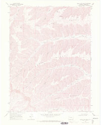
1968 Map of Middle Dry Fork
USGS Topo · Published 1972About this map
Kimball Mountain and Cow Ridge dominate this section of the Western Slope, where the topography is defined by the complex drainage of the North Fork Dry Creek. Surveyed in the late 1960s, the map reveals a landscape primarily accessed by historic pathways rather than developed roads. The ancient Ute Trail crosses the northern plateau near Big Salt Wash, while other routes like the Cuddy Ranch Trail and the Pack Trail suggest a reliance on horse and livestock movement. Water sources are the critical landmarks in this arid environment, marked by numerous named points such as Blanc Spring, McKay Spring, and Myser Spring. Evidence of early resource exploration is found at a Prospect near Kimball Creek, highlighting the region's history of small-scale mining and ranching interests during the mid-20th century.
Find a feature on this map
25 named features on this map. Tap any name to fly to it.
Don’t see what you’re looking for? This feature index may not catch every label — zoom into the map to look around manually.
Map Details
Editions of this 1968 Middle Dry Fork Map
2 editions found
Other maps of this area

1929 · Highmore
USGS Topo · 1:62,500

1929 · Roan Creek
USGS Topo · 1:62,500

1956 · Grand Junction
USGS Topo · 1:250,000

1959 · Grand Junction
USGS Topo · 1:250,000

1960 · Grand Junction
USGS Topo · 1:250,000

1962 · Grand Junction
USGS Topo · 1:250,000

1964 · Grand Junction
USGS Topo · 1:250,000

1964 · Henderson Ridge
USGS Topo · 1:24,000

1964 · Calf Canyon
USGS Topo · 1:24,000

1965 · Grand Junction
USGS Topo · 1:250,000