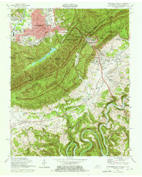
1974 Map of Middlesboro South
USGS Topo · Published 1976About this map
Cumberland Mountain dominates this mid-1970s landscape, serving as a towering backdrop for the tri-state junction where Kentucky, Tennessee, and Virginia meet. The city of Middlesboro occupies the broad valley to the northwest, defined by its grid of streets and the winding Yellow Creek. This area is a critical corridor for transport and education, featuring the sprawling campus of Lincoln Memorial University and the path of the Southern Railway.
Find a feature on this map
93 named features on this map. Tap any name to fly to it.
Don’t see what you’re looking for? This feature index may not catch every label — zoom into the map to look around manually.
Map Details
Editions of this 1974 Middlesboro South Map
3 editions found
Other maps of this area

1886 · Cumberland Gap
USGS Topo · 1:125,000

1888 · Cumberland Gap
USGS Topo · 1:125,000

1891 · Cumberland Gap
USGS Topo · 1:125,000

1897 · Maynardville
USGS Topo · 1:125,000

1900 · Maynardville
USGS Topo · 1:125,000

1903 · Middlesboro
USGS Topo · 1:48,000

1927 · Middlesboro
USGS Topo · 1:62,500

1930 · Middlesboro
USGS Topo · 1:62,500

1935 · Varilla
USGS Topo · 1:24,000

1935 · Mingo Mountains
USGS Topo · 1:24,000