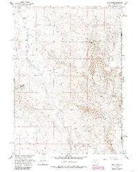
1957 Map of Miles Ranch
USGS Topo · Published 1985About this map
High-altitude ranching and the complex drainage of the Wind River Basin define this mid-century survey of the Wyoming landscape. Miles Ranch sits along a narrow riparian corridor in the northeast, where the terrain breaks into a series of steep drainages. The convergence of West Canyon Creek and East Canyon Creek demonstrates the seasonal water reliance of this arid region, supported by infrastructure like a isolated Well and a Corral for livestock management. To the west, Thompson Ranch occupies a high bench above the winding Canyon, while the unique erosional forms of Castle Gardens stand as a prominent landmark. A north-south Pipeline cuts across the western sections, signaling the arrival of industrial utility alongside traditional homesteading near Fraser Draw and the Fremont and Natrona County line.
Find a feature on this map
12 named features on this map. Tap any name to fly to it.
Don’t see what you’re looking for? This feature index may not catch every label — zoom into the map to look around manually.
Map Details
Editions of this 1957 Miles Ranch Map
3 editions found

Other maps of this area

1952 · Seventy-one Reservoir
USGS Topo · 1:24,000

1952 · Ervay Basin SW
USGS Topo · 1:24,000

1952 · Arminto SW
USGS Topo · 1:24,000

1952 · Love Ranch
USGS Topo · 1:24,000

1952 · Gas Hills
USGS Topo · 1:24,000

1952 · Puddle Springs
USGS Topo · 1:24,000

1952 · Moneta SE
USGS Topo · 1:24,000

1952 · Miles Ranch
USGS Topo · 1:24,000

1952 · Ervay Basin
USGS Topo · 1:24,000

1955 · Arminto
USGS Topo · 1:250,000