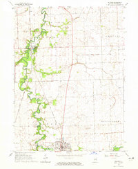
1964 Map of Milford
USGS Topo · Published 1965About this map
Sugar Creek defines the local topography of Iroquois County as it meanders through Milford and Belmont townships. This mid-century landscape is dominated by agricultural fields and the vital north-south corridor of the Chicago and Eastern Illinois railroad, which links the settlements of Milford and Woodland. The map reveals a high concentration of family and community burial grounds, including Maple Grove Cem, Vennum Cem, and Body Cem, providing significant data for genealogical research. Aviation infrastructure is surprisingly prevalent for a rural quadrangle, featuring both the Milford Airport and the Newman Landing Strip. The presence of a Gaging Station and various drainage features like Possum Trot Ditch highlight the ongoing efforts to manage the water levels of the surrounding prairie and creek beds.
Find a feature on this map
22 named features on this map. Tap any name to fly to it.
Don’t see what you’re looking for? This feature index may not catch every label — zoom into the map to look around manually.
Map Details
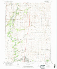
Editions of this 1964 Milford Map
2 editions found
Other maps of this area

1935 · Watseka
USGS Topo · 1:48,000

1938 · Milford
USGS Topo · 1:48,000

1939 · Watseka
USGS Topo · 1:62,500

1939 · Cissna Park
USGS Topo · 1:62,500

1944 · Milford
USGS Topo · 1:62,500

1944 · Gilman
USGS Topo · 1:62,500

1946 · Gilman
USGS Topo · 1:62,500

1949 · Cissna Park
USGS Topo · 1:62,500

1953 · Danville
USGS Topo · 1:250,000

1955 · Danville
USGS Topo · 1:250,000