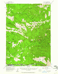
1955 Map of Mill City
USGS Topo · Published 1961About this map
The Little North Fork Santiam River and the main Santiam River carve through this landscape during a period of active timber and mineral extraction. Settlements like Mill City and Gates anchor the southern corridor, where the S P RR tracks follow the river's path through the mountains. This mid-century survey captures the industrial footprint of the Willamette National Forest before modern expansion, documented by the presence of the Lake Logging Camp and the Pearl Creek Guard Sta. Higher elevations are dotted with legacies of the region's mining history, including the Gold Mtn Mine, Bonanza Mine, and Black Eagle Mine. The network of steep timber access routes such as the Molalla Forest Road and Butte Basin Road reveals how the rugged geography was navigated for resource transport between Clackamas and Marion counties.
Find a feature on this map
86 named features on this map. Tap any name to fly to it.
Don’t see what you’re looking for? This feature index may not catch every label — zoom into the map to look around manually.
Map Details
Editions of this 1955 Mill City Map
3 editions found

Other maps of this area

1916 · Estacada
USGS Topo · 1:125,000

1929 · Mill City
USGS Topo · 1:125,000

1939 · Molalla
USGS Topo · 1:62,500

1940 · Molalla
USGS Topo · 1:62,500

1948 · Vancouver
USGS Topo · 1:250,000

1950 · Vancouver
USGS Topo · 1:250,000

1950 · Vancouver
USGS Topo · 1:250,000

1951 · Lyons
USGS Topo · 1:62,500

1951 · Snow Peak
USGS Topo · 1:62,500

1953 · Salem
USGS Topo · 1:250,000