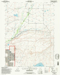
1992 Map of Millbrook
USGS Topo · Published 1996About this map
Hatton and the scattered family holdings of the Wyoming high plains define this landscape as it appeared in the early 1990s. The northern reaches are characterized by a network of ranching homesteads such as Whitney Ranch, Loban Ranch, and Forbes Ranch, all supported by an intricate system of water management including the Hecht and Farrell Ditch and the Mammoth Canal. The Little Laramie River winds through the western terrain, while the massive Lake Hattie Reservoir anchors the southern boundary. Transportation and trade are etched into the map via the Union Pacific rail line and historical routes like the Overland Trail. From the heights of Table Mountain to the localized community center at Millbrook Sch, this survey captures a specialized ranching economy reliant on gravity-fed irrigation and iron rails.
Find a feature on this map
41 named features on this map. Tap any name to fly to it.
Don’t see what you’re looking for? This feature index may not catch every label — zoom into the map to look around manually.
Map Details
Editions of this 1992 Millbrook Map
2 editions found
Other maps of this area

1895 · Laramie
USGS Topo · 1:125,000

1902 · Laramie
USGS Topo · 1:125,000

1905 · Laramie
USGS Topo · 1:125,000

1906 · Medicine Bow
USGS Topo · 1:125,000

1906 · Laramie
USGS Topo · 1:125,000

1908 · Laramie
USGS Topo · 1:125,000

1908 · Medicine Bow
USGS Topo · 1:125,000

1954 · Cheyenne
USGS Topo · 1:250,000

1954 · Rawlins
USGS Topo · 1:250,000

1958 · Rawlins
USGS Topo · 1:250,000