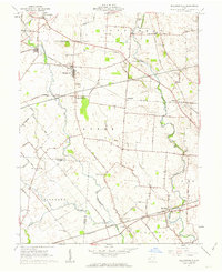
1961 Map of Milledgeville
USGS Topo · Published 1963About this map
Milledgeville and the surrounding agricultural townships of Jasper, Union, and Richland define this corner of the Virginia Military District in the early 1960s. The landscape is a network of rural routes like Ohio Miami Trace Road and Bloomingburg New Holland Rd that connect small rail-oriented settlements such as West Lancaster, Octa, and Jasper Mills. The confluence of the Baltimore and Ohio RR and Pennsylvania RR lines highlights the area's role as a transit corridor for Fayette and Clinton Counties. Many family-named landmarks and smaller cemeteries, including Hagler Cem and Mallow-Perrill Cem, remain as identifiers of the local genealogy. Waterways like Rattlesnake Creek and Sugar Creek carve through the farm lots, providing the primary natural drainage for the region's productive tillable land.
Find a feature on this map
65 named features on this map. Tap any name to fly to it.
Don’t see what you’re looking for? This feature index may not catch every label — zoom into the map to look around manually.
Map Details
Editions of this 1961 Milledgeville Map
Other maps of this area

1906 · Mt Sterling
USGS Topo · 1:62,500

1916 · Octa
USGS Topo · 1:62,500

1917 · Greenfield
USGS Topo · 1:62,500

1917 · Sabina
USGS Topo · 1:62,500

1943 · Sabina
USGS Topo · 1:62,500

1944 · Greenfield
USGS Topo · 1:62,500

1944 · Octa
USGS Topo · 1:62,500

1947 · Columbus
USGS Topo · 1:250,000
1960 · New Martinsburg
USGS Topo · 1:24,000

1961 · Columbus
USGS Topo · 1:250,000