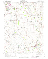
1961 Map of Milledgeville
USGS Topo · Published 1975About this map
Milledgeville and the surrounding farmland of Jasper and Jefferson townships are defined by a meticulous grid of rural roads and the winding course of Rattlesnake Creek. This 1961 survey captures a landscape steeped in family-named landmarks and local history, where small crossroad settlements like Octa and West Lancaster are connected by the Baltimore and Ohio and Penn Central railroads. The map is particularly rich for genealogical research, documenting numerous burial sites such as the Jefferson-Jasper Township Cemetery and the Old Creamer Cem.
Find a feature on this map
73 named features on this map. Tap any name to fly to it.
Don’t see what you’re looking for? This feature index may not catch every label — zoom into the map to look around manually.
Map Details
Editions of this 1961 Milledgeville Map
Other maps of this area

1906 · Mt Sterling
USGS Topo · 1:62,500

1916 · Octa
USGS Topo · 1:62,500

1917 · Greenfield
USGS Topo · 1:62,500

1917 · Sabina
USGS Topo · 1:62,500

1943 · Sabina
USGS Topo · 1:62,500

1944 · Greenfield
USGS Topo · 1:62,500

1944 · Octa
USGS Topo · 1:62,500

1947 · Columbus
USGS Topo · 1:250,000
1960 · New Martinsburg
USGS Topo · 1:24,000

1961 · Columbus
USGS Topo · 1:250,000