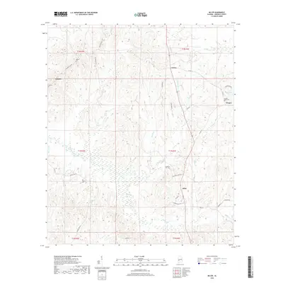
2018 Map of Miller
USGS Topo · Published 2018About this map
Miller and the surrounding rural communities of Octagon, Calvary, and Rembert anchor this study of the Marengo County landscape. The area is defined by a dense network of watercourses, including the central Beaver Creek and the southern reaches of Mud Rush Cr, which carve through the terrain. Numerous small family or community-based landmarks such as Berry Chapel and the Octagon Baptist Cem offer points of interest for those researching local lineage.
Find a feature on this map
49 named features on this map. Tap any name to fly to it.
Don’t see what you’re looking for? This feature index may not catch every label — zoom into the map to look around manually.
Map Details
Editions of this 2018 Miller Map
This is the sole edition of this map. No revisions or reprints were ever made.
Other maps of this area

1953 · Montgomery
USGS Topo · 1:250,000

1956 · Montgomery
USGS Topo · 1:250,000

1957 · Montgomery
USGS Topo · 1:250,000

1968 · Thomaston West
USGS Topo · 1:24,000

1970 · Myrtlewood North
USGS Topo · 1:24,000

1970 · Linden
USGS Topo · 1:24,000

1978 · Surginer
USGS Topo · 1:24,000

1978 · Sweet Water
USGS Topo · 1:24,000
1978 · Nanafalia
USGS Topo · 1:24,000
1978 · Myrtlewood South
USGS Topo · 1:24,000