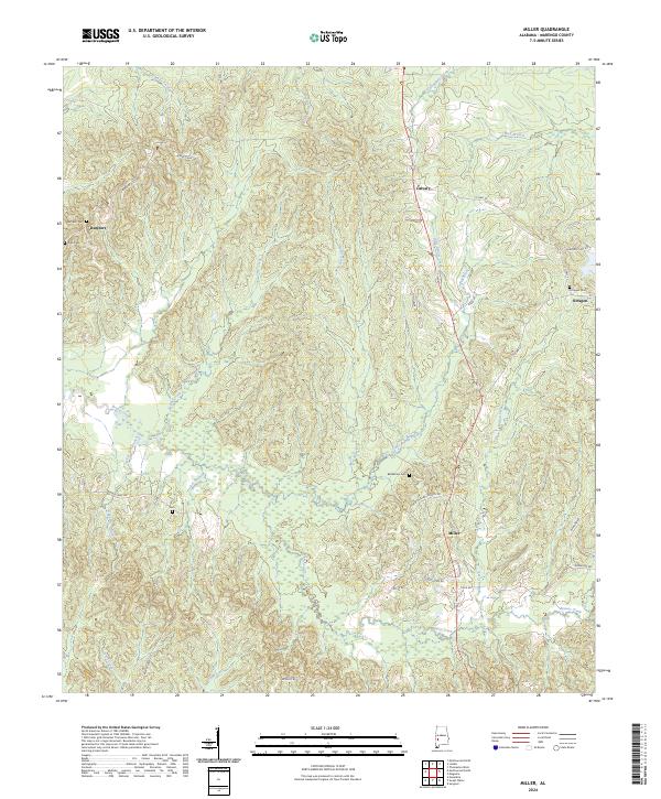
2024 Map of Miller
USGS Topo · Published 2024About this map
The community of Miller sits at a crossroads in southeastern Marengo County, anchoring a landscape defined by its intricate drainage network and dispersed rural settlements. This modern survey illustrates the persistent importance of early church and cemetery sites in the Black Belt region, including Zion Gem near Rembert and the Bethlehem Cem located off Bethlehem Church Rd. The terrain is characterized by numerous small watercourses like Mud Rush Creek, Threemile Creek, and Turkey Pen Branch, which feed into larger systems such as Beaver Creek. To the north, the small centers of Calvary and Octagon maintain their historical footprints, with the Octagon Cem serving as a local landmark. The winding secondary road system, including Co Hwy 33 and Marengo Lake Rd, follows the subtle ridges between these creeks, reflecting a traditional settlement pattern adapted to the wet lowlands of the Alabama interior.
Find a feature on this map
45 named features on this map. Tap any name to fly to it.
Don’t see what you’re looking for? This feature index may not catch every label — zoom into the map to look around manually.
Map Details
Editions of this 2024 Miller Map
This is the sole edition of this map. No revisions or reprints were ever made.
Other maps of this area

1953 · Montgomery
USGS Topo · 1:250,000

1956 · Montgomery
USGS Topo · 1:250,000

1957 · Montgomery
USGS Topo · 1:250,000

1968 · Thomaston West
USGS Topo · 1:24,000

1970 · Myrtlewood North
USGS Topo · 1:24,000

1970 · Linden
USGS Topo · 1:24,000

1978 · Surginer
USGS Topo · 1:24,000

1978 · Sweet Water
USGS Topo · 1:24,000
1978 · Nanafalia
USGS Topo · 1:24,000
1978 · Myrtlewood South
USGS Topo · 1:24,000