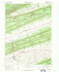
1968 Map of Millheim
USGS Topo · Published 1971About this map
The borough of Millheim and the historic village of Aaronsburg anchor this 1968 landscape, characterized by the alternating ridges and valleys of Central Pennsylvania. The terrain is defined by a sequence of steep mountains, including Nittany Mountain, Brush Mountain, and Shriner Mountain, which separate fertile agricultural strips like Miles Valley and Penn Valley. The drainage of Penns Creek and Fishing Creek provides the primary water source for the region's agricultural and early industrial base.
Find a feature on this map
67 named features on this map. Tap any name to fly to it.
Don’t see what you’re looking for? This feature index may not catch every label — zoom into the map to look around manually.
Map Details
Editions of this 1968 Millheim Map
4 editions found
Other maps of this area

1921 · Howard
USGS Topo · 1:48,000

1921 · Lock Haven
USGS Topo · 1:62,500

1923 · Howard
USGS Topo · 1:62,500

1923 · Lock Haven
USGS Topo · 1:62,500

1924 · Centre Hall
USGS Topo · 1:62,500

1929 · Centre Hall
USGS Topo · 1:62,500

1937 · Millheim
USGS Topo · 1:48,000

1941 · Millheim
USGS Topo · 1:62,500

1943 · Lewistown
USGS Topo · 1:125,000

1944 · Lock Haven
USGS Topo · 1:62,500