
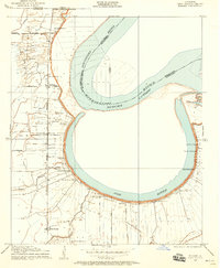
1909 Map of Millikin
USGS Topo · Published 1909About this map
Cotton plantation life and the shifting hydrology of the Mississippi delta define this 1909 survey of northeast Louisiana. Large agricultural estates like Ashton Plantation and Gossypia Plantation dominate the landscape, following the fertile curves of the Mississippi River. The presence of Old River highlights the dynamic nature of the river’s course, where abandoned meanders created rich bottomlands for settlement. Along the western edge, the Iron Mountain and Southern Railroad provides a critical transit corridor, supporting small communities and schools like Millikin School. Local commerce and social hubs are clearly marked, from the Bells of the Bend Store near the riverbank to a series of rural houses of worship including New Bethel Church and Rose Hill Church. An Indian Mound near Panola Plantation provides a rare link to the ancient inhabitants of this alluvial plain.
Find a feature on this map
31 named features on this map. Tap any name to fly to it.
Don’t see what you’re looking for? This feature index may not catch every label — zoom into the map to look around manually.
Map Details
Editions of this 1909 Millikin Map
2 editions found
Other maps of this area

1909 · Baxter Bayou
USGS Topo · 1:24,000

1909 · Lake Providence
USGS Topo · 1:24,000

1909 · Wilsons Point
USGS Topo · 1:24,000

1909 · Ashton Bridge
USGS Topo · 1:24,000

1911 · Lake Providence
USGS Topo · 1:31,680

1911 · Baxter Bayou
USGS Topo · 1:24,000

1912 · Ashton Bridge
USGS Topo · 1:31,680

1913 · Wilson Point
USGS Topo · 1:31,680

1914 · Baxter Bayou
USGS Topo · 1:31,680

1935 · Oak Grove
USGS Topo · 1:62,500