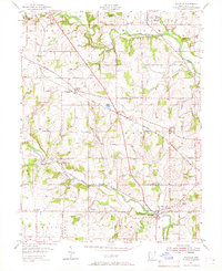
1955 Map of Millville
USGS Topo · Published 1966About this map
Indian Creek and Fourmile Creek carve distinct valleys through this mid-1950s Butler County landscape, dictating the placement of early settlements and roads. The Baltimore and Ohio Railroad serves as a primary transit corridor, cutting diagonally across the terrain near Woods Station and McGonigle. In the southeast, the village of Millville sits at the confluence of several local runs, while to the north, the outskirts of Oxford reveal early cemeteries such as Woodside Cem and Oxford Cem.
Find a feature on this map
50 named features on this map. Tap any name to fly to it.
Don’t see what you’re looking for? This feature index may not catch every label — zoom into the map to look around manually.
Map Details
Editions of this 1955 Millville Map
4 editions found
Other maps of this area

1911 · Oxford
USGS Topo · 1:62,500

1915 · College Corner
USGS Topo · 1:48,000

1915 · Harrison
USGS Topo · 1:48,000

1915 · Hamilton
USGS Topo · 1:62,500

1917 · Hamilton
USGS Topo · 1:62,500

1918 · College Corner
USGS Topo · 1:62,500

1953 · Cincinnati
USGS Topo · 1:250,000

1955 · Harrison
USGS Topo · 1:24,000

1955 · Hamilton
USGS Topo · 1:24,000

1955 · Reily
USGS Topo · 1:24,000