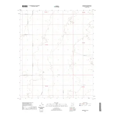
2020 Map of Milnesand NW
USGS Topo · Published 2020About this map
Eagle Hill Cem stands as a solitary historical landmark in this corner of Roosevelt County, a region characterized by the expansive grid of the Public Land Survey System. The landscape is defined by its rectilinear organization, with township and range lines like t7s r34e and t8s r35e carving the High Plains into regular sections. This modern digital survey by the U.S. Geological Survey captures the specialized road network essential for local transport and ranching access. Primary east-west travel is facilitated by State Hwy 258, while a series of numbered local routes including S Roosevelt Road 35 and S Roosevelt Road Z provide a high degree of connectivity across the open terrain. The lack of concentrated urban development highlights the area's rural character, where small, named features like cemeteries often serve as the primary markers of settlement history and genealogy.
Find a feature on this map
16 named features on this map. Tap any name to fly to it.
Don’t see what you’re looking for? This feature index may not catch every label — zoom into the map to look around manually.
Map Details
Editions of this 2020 Milnesand NW Map
This is the sole edition of this map. No revisions or reprints were ever made.
Other maps of this area

1954 · Brownfield
USGS Topo · 1:250,000

1958 · Brownfield
USGS Topo · 1:250,000

1962 · Brownfield
USGS Topo · 1:250,000

1972 · Milnesand SW
USGS Topo · 1:24,000

1972 · Milnesand
USGS Topo · 1:24,000

1972 · Dora SW
USGS Topo · 1:24,000

1972 · Crossroads
USGS Topo · 1:24,000
1972 · Pep
USGS Topo · 1:24,000
1972 · Milnesand NW
USGS Topo · 1:24,000

1978 · Flying M Ranch
USGS Topo · 1:24,000